At GeoCatMin we combine geological information, geochemistry, geophysics, satellite and cadastral to help mining companies identify areas with greater potential, reduce exploration risks and optimize your investments.
Our process integrates advanced technologies, geospatial analysis and artificial intelligence to convert large volumes of information into strategic decisions and concrete results.
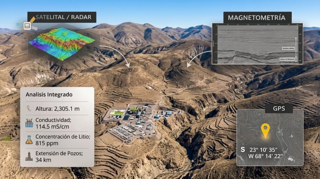
1. Data Collection and IntegrationArea of interest.
2. Advanced Geological Analysis
3. Design of Exploration Strategies
4. Comprehensive Evaluation of Mining Potential
5. Results and Decision Making
A practical example of our work methodology:
GEOLOGICAL ASSESSMENT REPORT AND PRELIMINARY EXPLORATION PROPOSAL
PROJECT: “GOLDEN SOCIETY” (CODE: 010326026)
TO: LUIS CANO VITE AND OTHERS
DATE: July 2026
PREPARED BY: Terrestrial Geological Technical Support Consulting
1. EXECUTIVE SUMMARY
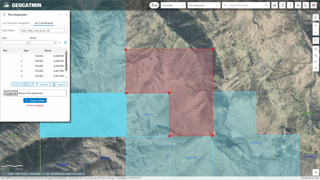
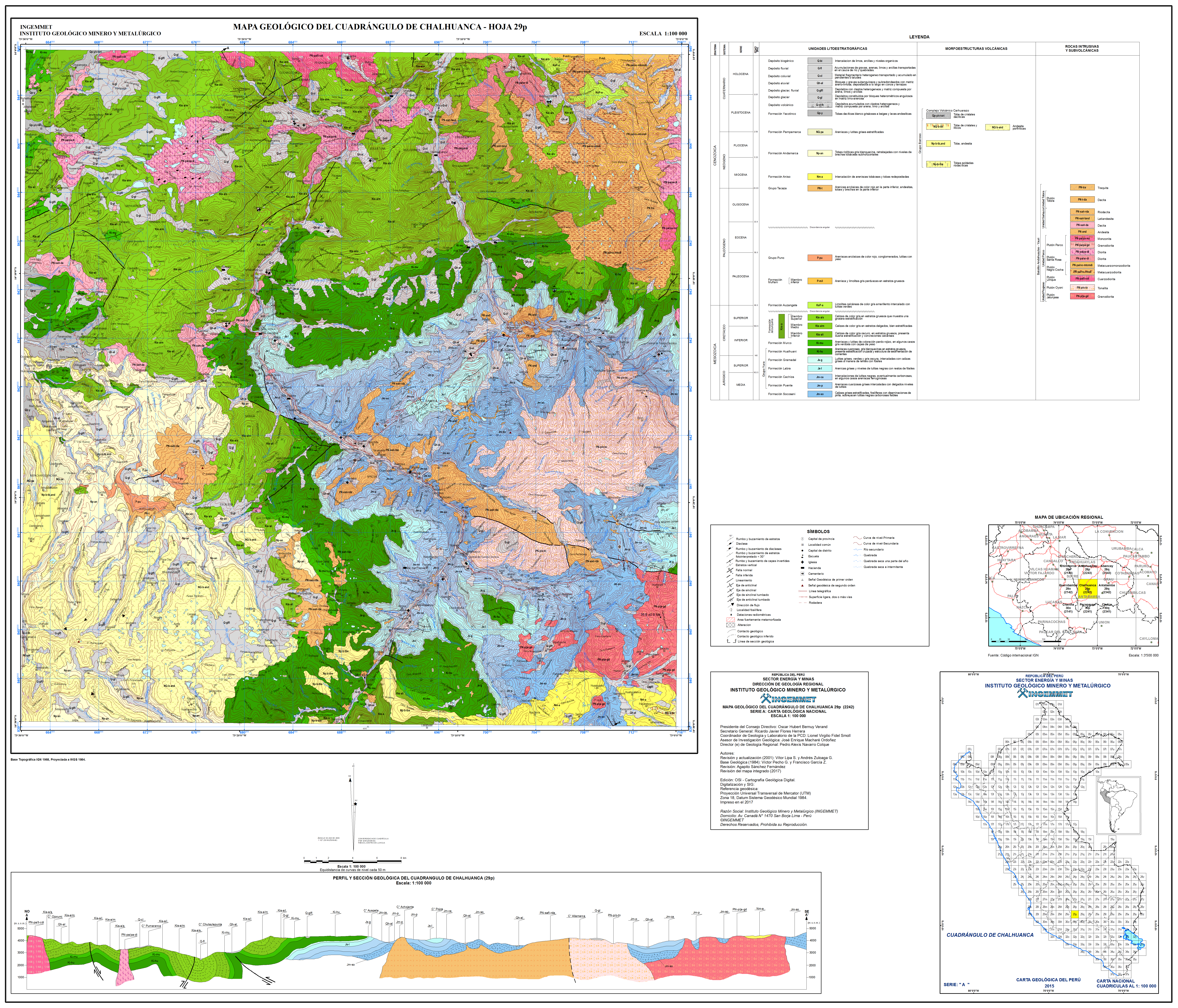
This report consolidates the office analysis, metallogenic interpretation and logistical planning for the mining concession“GOLDEN SOCIETY” (300 hectares), located in the district of Chapimarca, Apurimac [3.3.1]. Through the integration of official INGEMMET geological cartography, updated cadastral data and regional petrographic reports, A favorable geological potential has been identified for the occurrence of type deposits.Copper-Gold Skarn (WITH their) and related gold-bearing quartz veins [1.4.1, 1.4.8].
The objective of this document is to provide the rights holder with a technical tool and an optimized field action plan of three (3) days to validate surface mineralization reducing operating costs [1.2.9].
2. GENERAL INFORMATION OF THE CONCESSION
2.1. Cadastral and Legal File
- Request Name: GOLDEN SOCIETY [3.3.1]
- File Code: 010326026 [3.3.1]
- Titular: LUIS CANO VITE AND OTHERS [3.3.1]
- Extension: 300.0000 Hectares [3.3.1]
- Current Status: PROCEDURE (Request submitted on12/06/2026) [1.2.8, 3.3.1]
- Substance: Metallic [1.2.8]
2.2. Geographic Location
- Region: Apurimac
- Province: Aymaraes
- District: Chapimarca / Tapayrihua
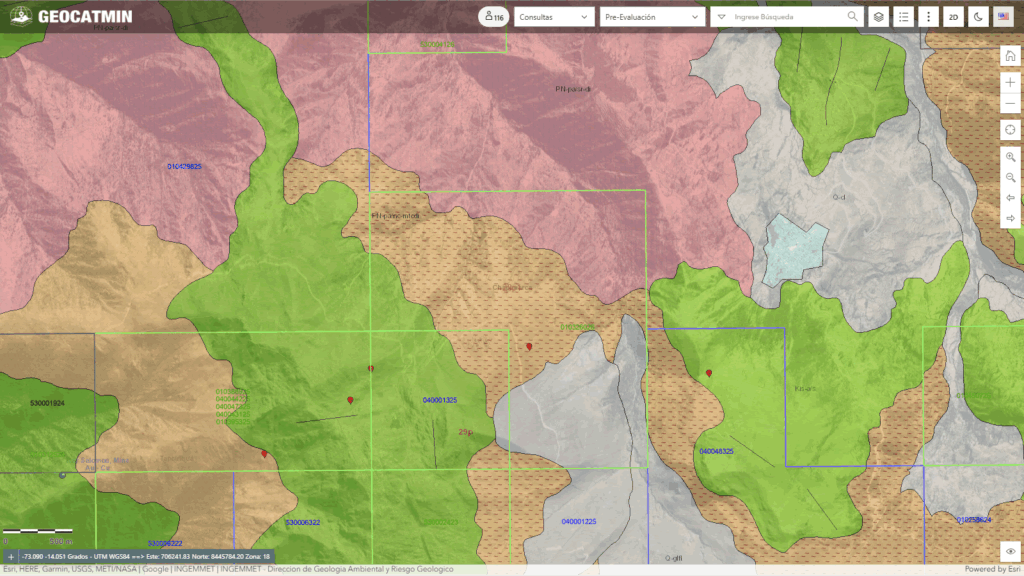
- Geological Quadrant: Hoja Chalhuanca (29-p), Scale 1:100,000 [1.1.1, 1.1.2]
2.3. Polygon Vertices (UTM coordinates – WGS84, Zone 18S)
The property has a geometry in the shape of “L” inverted defined by the following coordinates [1.1.9, 1.3.1]:
| Vertex | It is (X) | Norte (Y) | Area |
| 1 | 704,000 | 8,448,000 | 18S [1.1.9] |
| 2 | 704,000 | 8,446,000 | 18S [1.1.9] |
| 3 | 703,000 | 8,446,000 | 18S [1.1.9] |
| 4 | 703,000 | 8,447,000 | 18S [1.1.9] |
| 5 | 702,000 | 8,447,000 | 18S [1.1.9] |
| 6 | 702,000 | 8,448,000 | 18S [1.1.9] |
3. GEOLOGICAL FRAME, LITHOLOGICAL AND METALLOGICAL
The geology of the concession is governed by the interaction of intrusive magmatic rocks on a sequence of reactive sedimentary rocks., a classic atmosphereMetallogenic Belt of Porphyries and Cu-Au Skarns of the Andahuaylas-Yauri Batholith (Eocene-Oligocene) [1.2.2, 1.4.8].
3.1. Lithostratigraphic Units in the Area
- Parco Unit – Black Pluto Cocha (PN-pa/nc-mtcdi): It occupies most of the northern sector, center and east of the concession. It corresponds to ametacuarzodiorita ametacuarzomonzodiorita approximate age plutonic27.80 Ma (Oligocene). Its chemical composition (plagioclase 55%, quartz 15%, potassium feldspar 12%, biotite) describes it as a hydrated and oxidized magma, excellent metal carrier.
- Arcurquina Formation – Upper Member (Small-ar/s): It occupies the southwest sector and the western limit of the concession. Composed of massive gray limestone. Being carbonate rocks, act as a geochemical sink that neutralizes the acidic hydrothermal fluids of the intrusive, forcing the precipitation of copper and gold sulfides.
- Murco Formation (Ki-mu): Quartzite sandstones and limonites that crop out locally as structural support sequences.
3.2. Petrographic Evidence (Study of the Campione Ch-51 – INGEMMET)
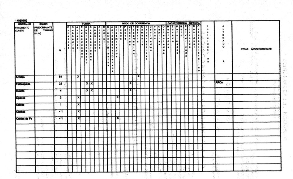
Regional petrographic analysis of clastic sedimentary rock (Feldspathic Wacka) In this area it reveals a strong impact of hydrothermal activity:
- Intense Argillic Alteration (64% clay matrix): The original feldspars have been altered to clays by the circulation of hot acidic fluids of magmatic origin..
- Presence of Opaque Metallics (2%): Recorded presence of disseminated opaque minerals (metal sulfides such as pyrite/chalcopyrite or magnetite). And 2% dissemination is a highly significant value for an early exploratory phase.
- Leaching and Iron Oxides: The report indicates that “iron oxide is staining minerals”, confirming processes of surface weathering of sulfides (creation of type anomaliesgossan or iron hat).
3.3. Structural Control and Close Analogs
- The property is located in an Andean fault zone. (NW-SE) that act as conduits for mineralizing solutions.
- A few meters outside the southwest limit of the concession, is located“My Solomons” (Have-With) [1.3.1], which is housed in the same limestone sequence of the Arcurquina Formation and under the same structural control, which suggests that the continuity of the mineralized system enters the concession “GOLDEN SOCIETY” [1.2.4, 1.3.1].
4. CHANCES OF FINDING MINERALS
In geological practice, The potential is evaluated by separating the physical probability of mineral existence from the commercial viability of the deposit:
- Geological Favorability Probability (Mineral presence): ~75% – 85%
- Livelihood: The geological environment is extremely favorable. The presence of reactive limestone (Small-ar/s) in direct contact with a fertile dioritic pluton (PN-pa/nc-mtcdi) of ~28 Ma (Parco Unit) is the perfect genetic model for the formation of copper-gold skarns. Additionally, the data of the ANAP Chalhuanca (Block 2 It is) adjacent reported gold values > 5 g/t and copper > 300 ppm in geologically equivalent areas [1.4.1].
- Probability of Economic Viability (Exploitable glacial): ~5% – 15%
- Livelihood: This is the standard rate in initial phases (green prospecting). Although the presence of mineralization is almost certain (gossan, minor veins, skarn marginal), only systematic geochemical sampling, geophysics and future diamond drilling will determine whether the volume (tonnage) and the average grade of metals justify the investment of a large-scale mining operation.
5. GEOLOGIST'S ACTION PIANO (FIELD CAMPAIGN 3 DAYS)
To optimize the use of resources, A quick three-day campaign has been planned with specific objectives per day, using as a basis theAccess Point and Parking in the coordinates703,100 AND / 8,446,100 N (Zone 18S) [1.1.9]:
Route of the Day 1: Contact Zone and Skarn Assessment (Southwest)
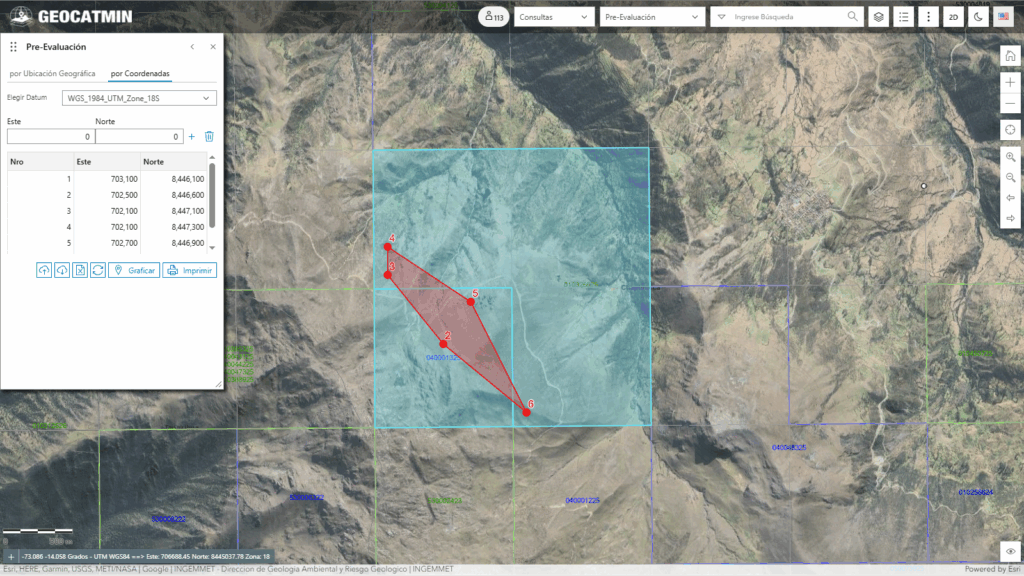
- Aim: Follow the direct intrusive-limestone contact in search of exoskarn zones and replacement bodies rich in magnetite, chalcopyrite and free gold.
| ID | It is (X) | Norte (Y) | Area | Tour Milestone |
| 1 | 703,100 | 8,446,100 | 32718 [1.1.9] | Starting Point (Parking) |
| 2 | 702,500 | 8,446,600 | 32718 [1.1.9] | Point 1 – Surface lithological contact |
| 3 | 702,100 | 8,447,100 | 32718 [1.1.9] | Point 2 – Western limit of the concession (Target Skarn) |
| 4 | 702,100 | 8,447,300 | 32718 [1.1.9] | Point 3 – Sampling of altered limestone in the high area |
| 5 | 702,700 | 8,446,900 | 32718 [1.1.9] | Point 4 – Return along the alteration slope |
| 6 | 703,100 | 8,446,100 | 32718 [1.1.9] | Return and Closing in Parcheggio |
Route of the Day 2: Exploration of Structures and Veins in the Intrusive (North Central)
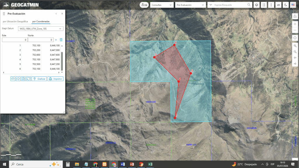
- Aim: Evaluate the internal faults of the metaquarzodiorite to detect possible quartz-gold-pyrite veins at depth.
| ID | It is (X) | Norte (Y) | Area | Tour Milestone |
| 1 | 703,100 | 8,446,100 | 32718 [1.1.9] | Starting Point (Parking) |
| 2 | 703,200 | 8,447,000 | 32718 [1.1.9] | Point 1 – Ascent to the center of the intrusive mass |
| 3 | 702,600 | 8,447,600 | 32718 [1.1.9] | Point 2 – Inspection of fractured faglia areas |
| 4 | 703,100 | 8,447,900 | 32718 [1.1.9] | Point 3 – Northern Limit (Santa Rosa Unit) |
| 5 | 703,500 | 8,447,200 | 32718 [1.1.9] | Point 4 – Return along the eastern ridge |
| 6 | 703,100 | 8,446,100 | 32718 [1.1.9] | Return and Closing in Parcheggio |
Route of the Day 3: Sediment Geochemistry and Sampling of the East Block (Southwest-East)
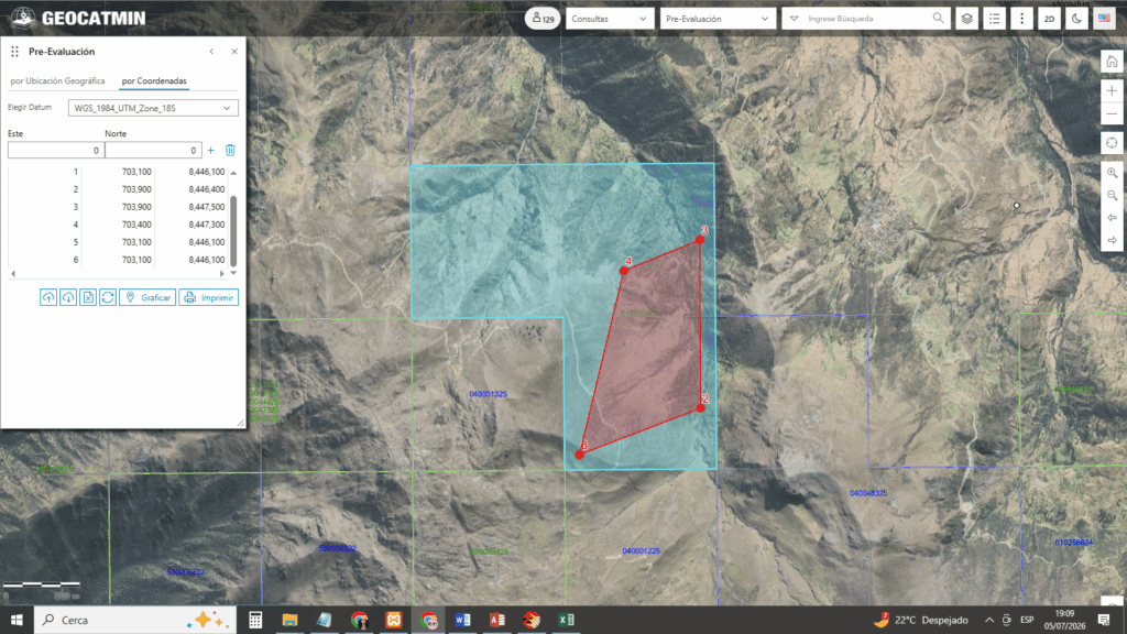
- Aim: Quickly discard the potential of the east block (predominantly intrusive) by systematically sampling stream sediments in local watersheds.
| ID | It is (X) | Norte (Y) | Area | Tour Milestone |
| 1 | 703,100 | 8,446,100 | 32718 [1.1.9] | Starting Point (Parking) |
| 2 | 703,900 | 8,446,400 | 32718 [1.1.9] | Point 1 – Entrance to the eastern ravine |
| 3 | 703,900 | 8,447,500 | 32718 [1.1.9] | Point 2 – Sampling of active river sediments |
| 4 | 703,400 | 8,447,300 | 32718 [1.1.9] | Point 3 – Return along eroded slopes |
| 5 | 703,100 | 8,446,100 | 32718 [1.1.9] | Return and Closing in Parcheggio |
5.4. Methodological Guidelines for the Field Geologist
- Route Flexibility: The geologist has the power to deviate from the geometric lines of the polygonal if he identifies outcrops with strong alteration., presence of malachite/azurite or structures with strong oxidation (gossan) [1.4.1].
- Zig-Zag Sampling (Day 1): Carry out transects perpendicular to the contact line to determine the width of the alteration halo. (endoskarn y exoskarn).
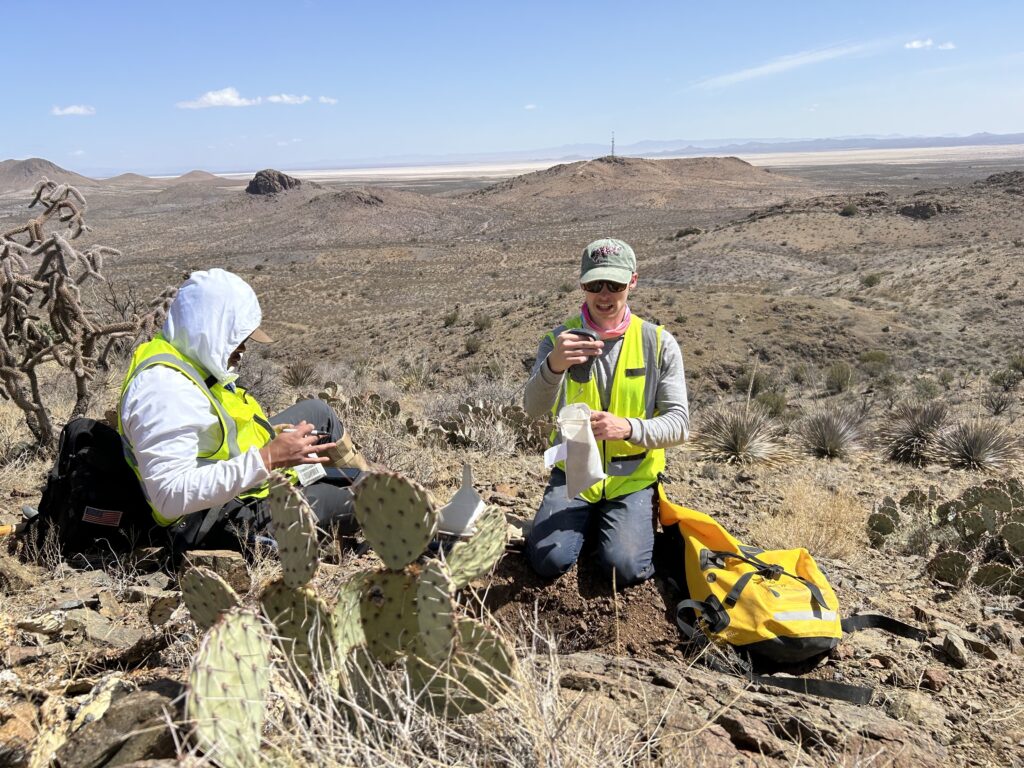
- Sample Registration: Each rock sample taken (rock chip) or sediments must be georeferenced with precision GPS, photographed wet and dry, and sealed in labeled plastic bags to avoid contamination.
- Sample Shipments: The collected samples will be sent to certified laboratories in Lima (p. ej., IF, SGS o Certimin) for multi-element ICP-MS analysis and fire testing for Gold.
6. RECOMMENDATIONS FOR FURTHER EXPLORATION
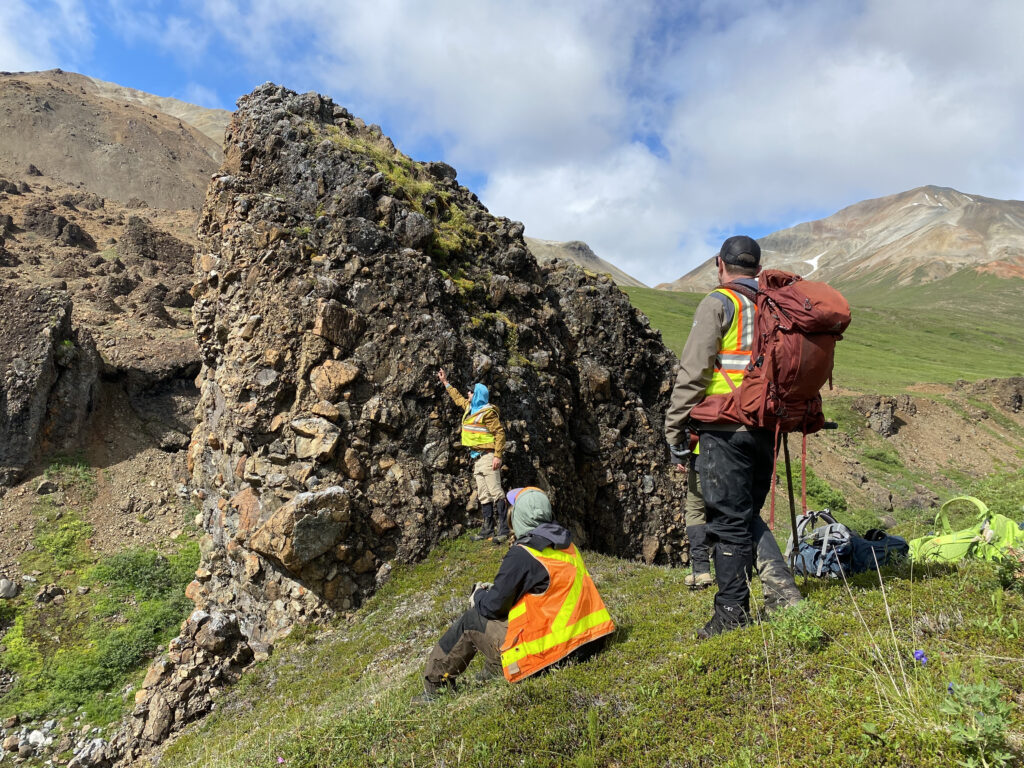
If the results of the sampling of this campaign are favorable, 3 days (golden laws > 0.5 g/t and copper > 0.4% in outcrop), It is recommended to proceed with:
- Detailed Scale Geological Mapping (1:5,000 o 1:2,000) on areas with proven anomalies.
- Terrestrial Geophysics Lines: Specifically Magnetometry (to outline the magnetite bodies of the skarn) and Induced Polarization (IP) to detect areas with sulfides disseminated at depth.
- Surface Land Agreements: Initiate early contacts with the local community (such as Ancobamba or communities in the Chapimarca district) to ensure long-term access for future diamond drilling platforms.